Weather or Not
 |
| From Dallas to Canadian, TX |
What do you make of the pilot's decision — that's me — to fly the red segment to KCDS, the Childress, TX airport, then change direction and follow the green route to the refueling stop KHHF, the Hemphill County airport in Canadian, TX?
Daring?
The green segment cuts through a yellow/orange/red area produced by radar. It warns of significant levels of rain. Nearby yellow lightning bolts indicate that systems augmenting radar have detected lightning. Taken together, it means that significant thunderstorms are ahead.
On top, all this is included in a large brown-shaded area for which a SIGMET (significant meteorological information) predicts major thunderstorms.
Flying into that mess seems like folly, doesn't it?
We include the picture here as part of a discussion how radar images and SIGMET predictions should guide a pilot's decisions.
Let's start.
With the advent of ADS-B and XM-Weather, pilots now have a lot of weather information on board, as demonstrated by the above picture.
What's a pilot to do with this information? The short answer is: Even though there is now a wealth of radar and weather-related information, it doesn't suffice for appropriate decision-making.
In other words: Cases that look terrifying may actually be benign, and benign-looking cases may actually be very dangerous. We discuss here four example cases.
Let's start with the above situation. Before we took off, we checked weather predictions of the NOAA's Prog Chart. It told that bad weather would exist along our route from Dallas to Canadian, TX, but that it would move from west to east.
That information was crucial for interpretation of the above picture. Since rain and thunderstorms were to move east, we could hope that this would indeed happen and that the route to the airport at Canadian would no longer be affected by the time we got to Childress.
That happened indeed, and the entire route had no rain, no thunderstorms, and clouds were high enough for safe VFR (Visual Flight Rules) flight.
Benign?
Take a look at the next case. It depicts the situation after we had refueled at Canadian and were on the next leg to Goodland, KS.
 |
| Last portion of route from Canadian, TX to Goodland, KS |
Given that the bad weather was moving to the east, we should have had no trouble reaching Goodland, right?
There was a ominous sign, though. The Kit Carson airport in Burlington, CO (KITR) had a yellow dot, meaning that it was IFR (instrument flight rules) and thus both the level of the clouds and the visibility did not meet the VFR conditions.
If the weather was truly moving east, that airport should have become VFR just like the Goodland airport KGLD with the blue dot.
Hence this called for close monitoring. It turned out that weather conditions at the Kit Carson airport never improved, indeed the entire surrounding area did not allow VFR flight.
Worse yet, the situation did not change as we approached the area, and we eventually diverted first to the west and then proceeded north to the Akron airport in Colorado.
The fact to be learned here: Weather predictions are just that. Always consider that they may turn out to be wrong and plan ahead for suitable alternatives.
In this case, eastern Colorado was wide open, indeed without any cloud, and we could proceed with a safe Plan B.
Terrifying?
Look at the following case. It depicts the end of a daylong trip that started in Rexburg, ID and terminated in Albuquerque, NM. A separate post covers the first part from Rexburg to Canyonlands, UT.
 |
| Canyonlands, UT to Albuquerque, NM |
The day started out with no rain let alone thunderstorms. But such weather was predicted for late afternoon, covering much of the area except for a large pie-shaped segment that included our route from Canyonlands to Albuquerque.
As we have seen, weather predictions need not come true. Hence from the start of the day, beginning in Rexburg, we monitored how the weather developed. More on that toward the end of this post. Hour after hour the prediction held.
After we had refueled in Canyonlands, the route to Albuquerque was still clear and no thunderstorms were moving towards that destination. Eventually we landed in Albuquerque with a significant crosswind that posed no problem for our plane.
Altogether, perfectly safe flying for the entire day.
Mistake?
The next picture shows part of our route the next day from Albuquerque to Dallas.
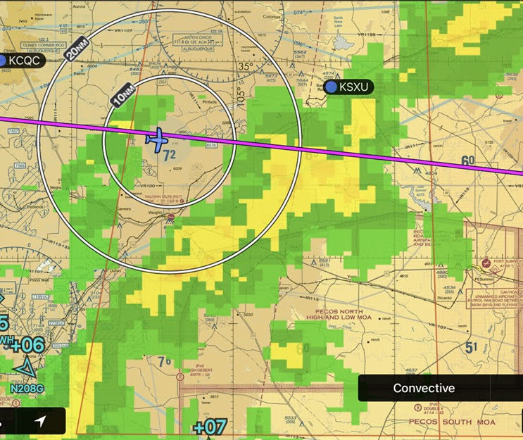 |
| On the route from Plainview, TX to Dallas |
We faced an area with significant rain, as indicated by the yellow color of the radar image. Was is safe to fly through that area?
Some facts: The clouds were at a comparatively high level, about 4,000 ft above ground. That information came from the weather data of nearby airports. Visibility was excellent. There was no lightning nearby or even farther away.
Altogether that meant that this was just some medium intensity rain, with no thunderstorm activity.
Flying into the area confirmed the analysis. We experienced significant rain that washed the plane, but there was no loss of visibility or turbulence. Altogether a benign event.
The entire trip, from Dallas to Teton NP and back, had been an extensive learning experience. Two lessons stand out.
Lesson 1: Analyze Prior Weather
At least two days before any long cross country flight start to monitor the weather predictions and check day by day to what extent they turn out to be correct.
These repeated checks establish to what extent we can trust the predictions for the planned flight.
Combine that knowledge with the weather data during the trip by ADS-B or XM Weather. The above four cases show that this combined analysis tells us what to do.
Always consider alternate options in case the original flight plan must be abandoned. This includes that planning for a significant amount of fuel for those alternatives.
Lesson 2: Monitor Everything During the Flight
We learned a really important rule from Chesley Sullenberger, the famous pilot who landed an Airbus in the Hudson River and saved the lives of all passengers.
Every 30 minutes, he would monitor the weather conditions at the destination airport.
We have expanded this. Every 30 minutes we go over the entire panel, check every instrument, verify that the radios have the frequencies for the next contacts.
Then we check weather conditions at every airport along the remainder of the route and verify that conditions remain favorable.
If we come upon a problem, such as the destination airport developing nasty wind conditions that will complicate the landing, we know about it early on and can develop suitable alternatives.
These rules were crucial for the trip to Teton NP and back.
Complacency?
Can we sit back and say, hey, we got everything under control?
That would be a big mistake. During every flight the pilot overlooks something, makes some mistake, doesn't handle an aspect well. We are no exception.
It's important to be aware of this human shortcoming. To counteract this, after every flight we go over details and analyze where we missed something.
The above trip was no exception. For example, we forgot to check the temperature at the Canyonlands airport.
When we landed, big surprise: It was 95 deg F! Oh my, this would complicate the takeoff and climb-out to altitude. Indeed, it wasn't easy. But nevertheless we managed to keep engine oil and coolant temperatures in the green.
The line technician filling the tanks told us that the temperature the day before had been 105 deg F. That would have made it virtually impossible to take off. By sheer luck we didn't arrive a day earlier.
Lesson learned: When selecting and monitoring airports, we won't just check the wind conditions, but also the temperature if there is any chance it might prevent the takeoff.
Have any question or feedback about this post? Please share your thoughts in the comments.


Comments
Post a Comment